About the Roundtop Mountain
Region

Difficulty

Length
Activities

Roundtop Mountain Passage including the new Carolina Hemlock Loop trail
This round-trip hike of approximately 5 miles begins and ends at the Sassafras Mountain parking area. The bonus of this trip is the short walk to the new observation deck atop Sassafras Mountain, the highest point in SC, which affords magnificent views of the surrounding area.
The hike begins on the Foothills Trail a short walk down the road to the trail entrance on the left with a Palmetto Trail sign. Continue on the Foothills Trail for almost 1 mile and The Palmetto Trail entrance is on the right, good sign and a kiosk is visible. The trail leads through a mature forest of mixed hardwoods, pine and the remnants of large hemlocks. There are good views in the winter of Lakes Jocassee and Keowee along the way. After about 1 1/4 miles the new Carolina Hemlock Loop trail leads off on the right and continues another 1 1/4 miles to join with the original route at the bottom of a set of steps. The way back to the “top” and Sassafras Mountain parking area is to the left.
Along the way the hiker will see many large Carolina Hemlocks that have been treated to protect them from the Hemlock Wooly Adelgid which is killing all of the unprotected Eastern and Carolina Hemlocks in the Southeast. The 1/2 mile woods road walk from the bottom entrance of the Carolina Hemlock Loop will rejoin the walk down closing the loop portion of the hike.
There is a great deal of elevation change and the return hike is mostly uphill and is steep at times. There is no water along the trail. This is a higher elevation hike and mountain weather can be unpredictable so go prepared.
Please note that the entire hike is in DNR game lands and beginning October 1 all hikers must wear a blaze orange hat or vest for safety as mandated by SC law.
Have questions about this hike? Contact Jim Kelly at jkelly@palmettoconservation.org
MORE ABOUT THE ROUNDTOP MOUNTAIN PASSAGE:
The passage adds a 5.1-mile forested footpath and creates opportunities for circular hikes in the Jocassee Gorges wilderness in Pickens County.
Roundtop Mountain Passage is located between the Foothills Trail and the Palmetto Trail’s Blue Ridge Electric Co-op Passage in the unique Jocassee Gorges. From the Sassafras Mountain overlook, hikers will travel about a mile down the Foothills Trail toward Table Rock State Park. Signs will identify the Palmetto Trail split, and a trailhead kiosk about 150 feet down the Roundtop Mountain Passage will display a map and other important information. The address for Sassafras Mountain overlook is 1399 F Van Clayton Memorial Hwy, Sunset, SC 29685. At 3,553 feet, Sassafras Mountain is the highest point in South Carolina.
The Roundtop Mountain Passage is accessed from the Sassafras Mountain parking area. Traveling approximately one mile from Sassafras Mountain, the highest point in South Carolina, toward Table Rock State Park along the Foothills Trail one discovers the intersection of the Roundtop Mountain Passage of the Palmetto Trail. This intersection is clearly signed detailing the direction to Table Rock State Park, to Sassafras Mountain, and to continue on the Palmetto Trail on the Roundtop Mountain Passage. About 150 feet from this intersection of trails, there is a kiosk with a map of the Roundtop Mountain Passage. Continuing along the trail you will be passing along a ridge that slowly rises to a rhododendron stand that is the current highpoint of the passage. From this high point there is a view of the North Carolina Mountains. This view is particularly fine during the winter season. The trail begins to descend along a ridge of open hard woods continuing down an abandoned woods road to an open food plot/meadow. At this point, there are future plans for a spur trail to a particularly protected and fine stand of Carolina Hemlocks at the summit of Roundtop Mountain. The trail continues to descend SCDNR’s access road, Roundtop Mountain Road. Along this road is an overlook to a view across Poplar Hollow Creek to the rock face of Rock Mountain. This spectacular rock face can only be seen from the ground at this overlook. The trail continues to descend to the intersection with SCDNR’s Poplar Hollow Road. The trail takes a left at this intersection and follows Poplar Hollow Road for 2+ miles to the intersection with SCDNR’s Horse Mountain Road. The trail continues to the right on Horse Mountain Road for about ¼ mile to the intersection of the Blue Ridge Electric Co-op Passage of the Palmetto Trail. At this intersection there are signs that direct you either to US-178, or to Table Rock State Park. Of note there is a campsite with a water source about ½ mile along the Blue Ridge Electric Co-op Passage toward Table Rock.
The connection now made with the Roundtop Passage and the Foothills Trail allows for two interesting weekend hiking options. The first is to begin at Jones Gap State Park. A second option is utilizing the Blue Ridge Electric Co-op Passage from Table Rock State Park, the Roundtop Mountain Passage, and the Foothills Trail back to Table Rock State Park for a 23+mile loop hike.
Interactive Maps Without Wifi
We have partnered with Avenza Maps in order to offer interactive maps that don't require an internet connection. Using the Avenza App, you can download maps onto your mobile device before you hit the trail, so that you locate yourself and be aware of where you are, even in the remotest of places. Offline location helps you stay on track, on the trail, and out of potential danger.
Get the Map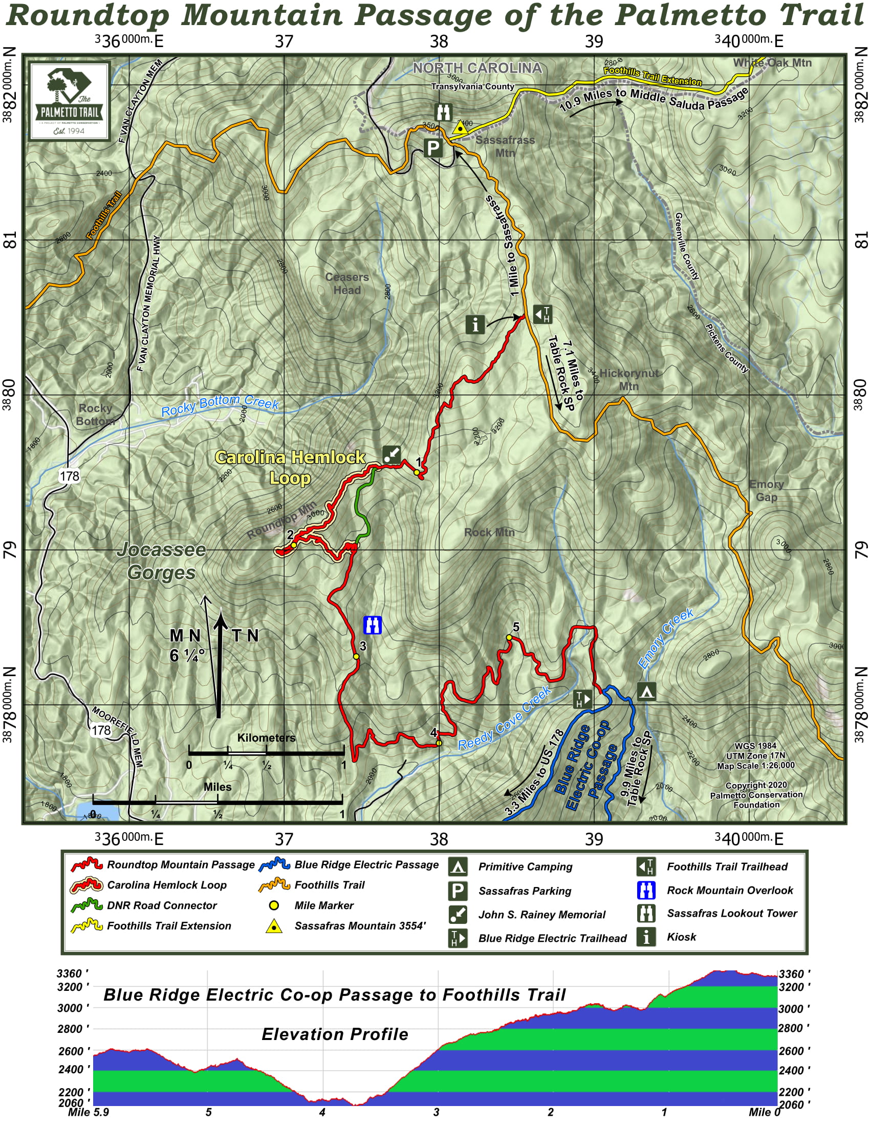
Roundtop Mountain Share Owners
Owen Garriott