About the Blue Wall Passage
Region

Difficulty

Length
Activities


NOTICE:
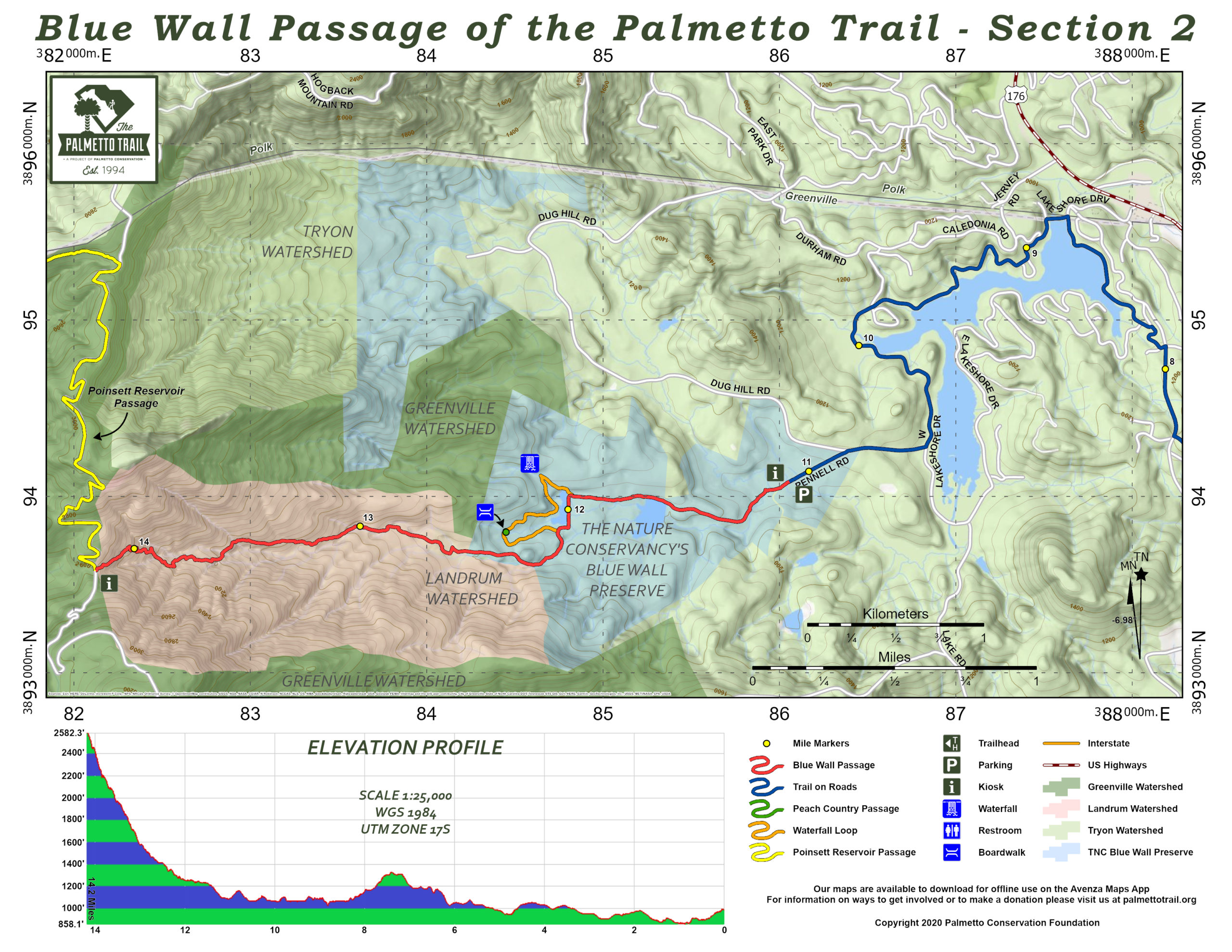
During this time, there is a surge in Trail usage across the state. We ask that if you are hiking the Blue Wall Passage that you only use the designated parking area and do NOT park on Doug Hill Road. This is in respect for our local property owners and for the safety of all Trail users. Thank You
Dogs must be leashed at all times
The Blue Wall Passage crosses pristine natural areas managed by The Nature Conservancy and home to more than 100 species of birds. Wildlife, scenery, and a 30-foot cascading waterfall on a side loop offer fantastic photo ops for nature lovers. The eastern trailhead is located in the Foothills Equestrian Nature Center (FENCE), an education/recreation center with easy paths, a pond, and an observation boardwalk. Country roads and sidewalks take the Trail user through downtown Landrum and around lovely Lake Lanier. The Southern Blue Ridge Escarpment at miles 12 to 14 climbs steeply and abruptly to Vaughns Gap (trailhead for Poinsett Reservoir Passage). Landrum offers quaint antique shops, great eateries, and comfy B&Bs.
Signs
Interactive Maps Without Wifi
We have partnered with Avenza Maps in order to offer interactive maps that don't require an internet connection. Using the Avenza App, you can download maps onto your mobile device before you hit the trail, so that you locate yourself and be aware of where you are, even in the remotest of places. Offline location helps you stay on track, on the trail, and out of potential danger.
Get the Map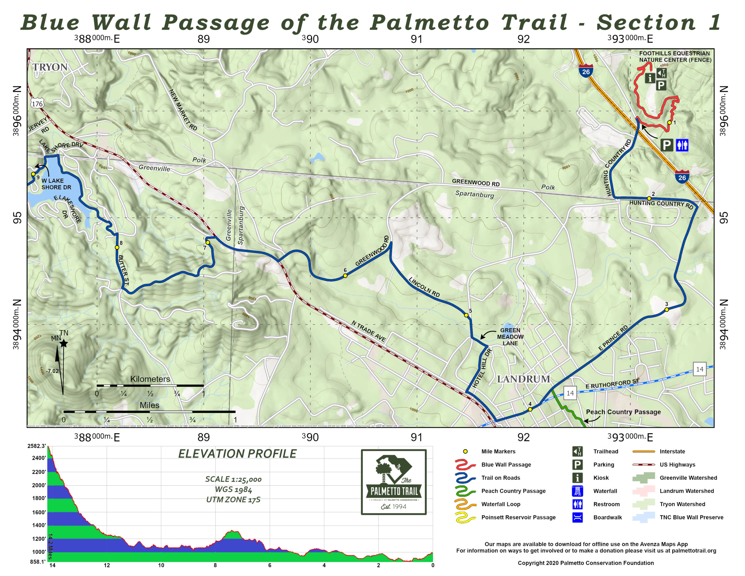
Directions
Trailhead at SC Nature Conservancy’s Blue Wall Preserve: From I-26 take exit 1 (SC Hwy 14) west toward Landrum. Turn right (north) on US Hwy 176, just after the railroad tracks. Drive approximately 2 miles and turn left onto Lakeshore Drive, the entrance to Lake Lanier. Follow Lakeshore Drive across the bridge. Then follow West Lakeshore Drive around the lake to Dug Hill Road (on right). The trailhead and parking are on the left about 500 feet down Dug Hill Road.
Trailhead at Foothills Equestrian Nature Center (FENCE): From I-26 take exit 1 (SC Hwy 14) west toward Landrum. Follow directional signs posted on Hwy 14 to FENCE. Drive 1.5 miles, and turn right onto Bomar Road. Go a short block and turn right onto East Prince Road for approximately 1.5 miles. Turn left onto Hunting Country Road (just before the I-26 overpass). Follow Hunting Country Road about a mile. After the I-26 underpass, the main entrance for the FENCE Center, hiking trails, and TROT barn is on the right.
Downtown Landrum Trailhead: From I-26 take exit 1 (SC Hwy 14) west toward Landrum. Drive about 2 miles and turn right onto North Trade Street just before the railroad tracks at the signal. Parking and the Palmetto Trail kiosk map are on the left.
Additional Information
The SC Nature Conservancy, 2231 Devine St, Columbia, SC 29205, ph (803) 254-9049
Foothills Equestrian Nature Center (FENCE), 3381 Hunting Country Rd, Tryon, NC 28782, ph (828) 859-9021
Please note that the Vaughns Gap trailhead, where the Blue Wall Passage connects to the Poinsett Reservoir Passage, can only be accessed by foot.
The Blue Wall Passage parking area is 3.4 miles from the trailhead at Vaughn’s Gap.
Blue Wall Passage Share Owners
Ed & Cynthia Chandler
Trey Cole
Bob Cutler
Dennis Dease
John Mark Durham
Clary Greenway
Ron & Catherine Hoffman & Pets
Thomas Lang
Matthew Lockhart
William Lowe
Linda Morten
Beth Reid
Jason & Sara Sain
Miriam Shelden
John C. Shelley
Elizabeth Spahr & Hope Mizzell
Jesse Tate
Mark Taylor
Field Wardlaw
Ron Ware
J. Randy Wilson
South Carolina Society Children of the American Revolution