About the Lake Moultrie Passage
Region

Difficulty

Length
Activities


CAUTION:
logging may be occurring between Viper and Springwood road along the trail. The trail is on the woods road not in the woods so mostly dealing with log trucks going in and out when they start back up.
The two hand pump wells at the primitive campsites inside the East and North Dikes of Lake Moultrie have been removed, as well as, at the Sandy Beach campsite on the spur trail inside North Dike.
There are currently no wells located at the primitive campsites. Please be sure to pack in enough water if you plan to camp.
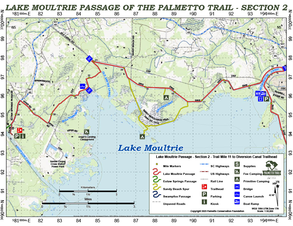
Scenic and popular Lake Moultrie Passage rings the eastern and northern shores of a 60,000-acre lake, and panoramic views are spectacular. Much of the passage shares Santee-Cooper’s service roads on the lake’s earthen levees, which makes the trail a favorite with mountain bikers. From the Hwy 52 trailhead, a short hike through pine forest opens to the Pinopolis East Dike, a perfect place for admiring sunsets. After a walk through Bonneau Beach, the trail continues along the north-shore dike system until it crosses historic Santee Canal. The last few miles pass through a mature hardwood and pine forest that includes fascinating swamp terrain around Bulltown Bay.
Signs
Interactive Maps Without Wifi
We have partnered with Avenza Maps in order to offer interactive maps that don't require an internet connection. Using the Avenza App, you can download maps onto your mobile device before you hit the trail, so that you locate yourself and be aware of where you are, even in the remotest of places. Offline location helps you stay on track, on the trail, and out of potential danger.
Get the Map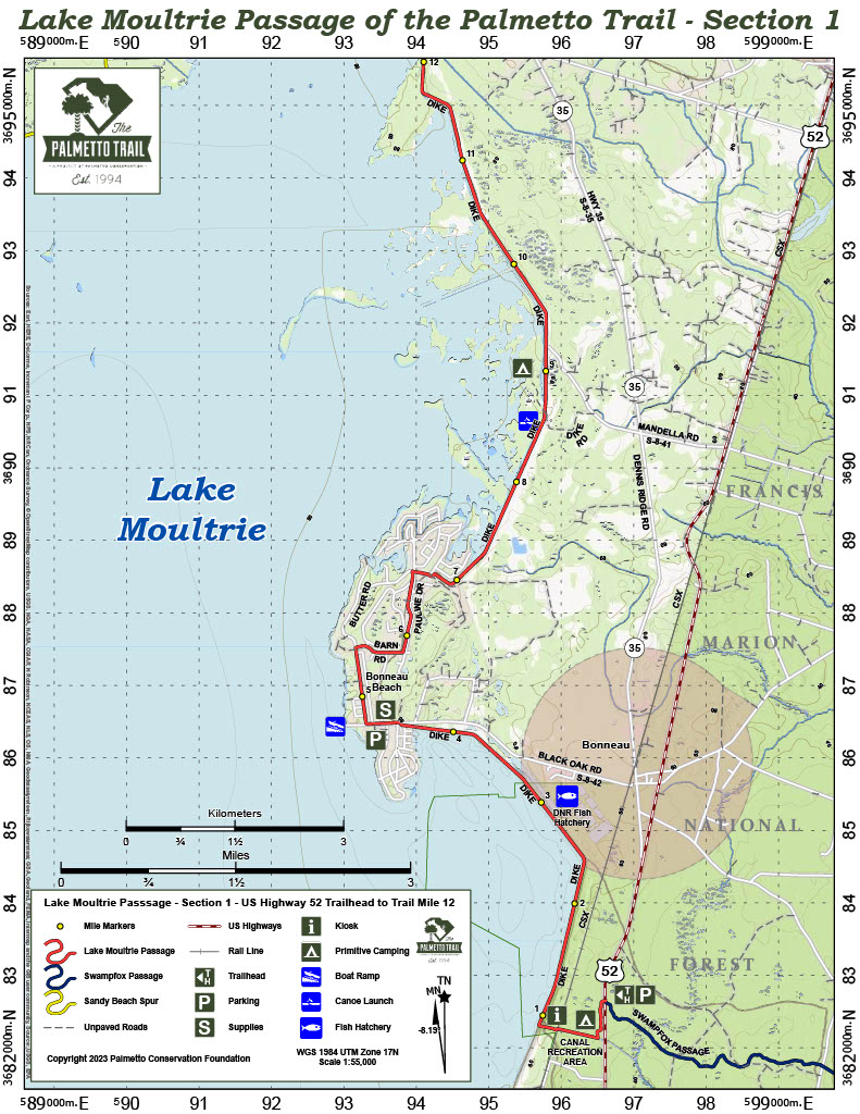

Directions
US Hwy 52 Trailhead (eastern)—From Moncks Corner, take US Hwy 52 north. Stay on US 52 about 3.8 miles past the split with US Hwy 17 Alt. Watch for neon yellow hiker highway sign. The trailhead and parking are on the right. Lake Moultrie Passage is across the highway.
Diversion Canal Trailhead (western): From I-26 exit 194, drive east on Jedburg Rd (S-8-16) to US 176. Cross 176 onto Cooper Store Rd. At 3.5 miles bear left and stay on Cooper Store Rd 9 miles to SC 6. Turn left and travel north 16.6 miles past Cross to SC 45. Turn right (east) toward St. Stephen. Travel 3 miles and turn right onto Eadie Lane (first dirt road after cross Diversion Canal). Follow Eadie Lane to the parking area along the canal. On foot or bike, travel back to SC 45, turn left and go 0.7 mile across the pedestrian walkway over the canal to Murphy Bay Rd. Turn left to continue on Eutaw Springs Passage.
Camping
NOTICE: The two hand pump wells at the primitive campsites inside the East and North Dikes of Lake Moultrie have been removed, as well as, at the Sandy Beach campsite on the spur trail inside North Dike.
There are currently no wells located at the primitive campsites. Please be sure to pack in enough water if you plan to camp.
3 night maximum on camping.
Notes
*No restrooms or water are available at the US Hwy 52 trailhead. The former Canal Recreation Area has been closed and decommissioned.
*Sandy Beach spur trail is closed from Nov 1 through Feb 8 to hiking/biking as this is a waterfowl management area. Deer hunting occurs from Sept 15- Oct 15 (M-Sat) so hiking/biking here during that period/days is not advised.
No hunting is allowed on Sundays. Hike and Bike this section from March 2 through Sept 14 and Oct 16- Oct 31. During big game season wear international orange. Consult SCDNR hunting dates and times at: http://www.dnr.sc.gov/regs/
Additional Information
Contact Supervisor-Forestry & Undeveloped Lands, Santee Cooper Land Division, One Riverwood Dr, Moncks Corner, SC 29461, ph (843) 761-8000.
Lake Moultrie Passage Share Owners
June Elizabeth Duggan
Donald Eadie
Pinckney Roberts
South Carolina Society Children of the American Revolution