About the Saluda Mountains Passage
Region

Difficulty

Length
Activities

NOTICE: Logging is currently underway between Talisman Camp Trailhead and Bell Mountain Road
Saluda Mountains Passage runs along the ridge defining the northern perimeter of the Poinsett Watershed and the border between the Carolinas. The 19,000-acre watershed is a pristine wilderness area with remarkable habitat for rare plants and animals, including the threatened Peregrine falcon. Greenville Water System (GW) owns the tract, which drains the headwaters of the North Saluda River into Poinsett Reservoir. The Nature Conservancy holds the conservation easement. GW permits hiking, but enforces strict rules in exchange for access. Please help Palmetto Conservation keep this passage open by following the rules. Note that many organisms in the streams have low tolerance for pollution. Practicing “Leave No Trace” is essential in this extraordinary ecosystem. The passage trailhead connects with Poinsett Reservoir Passage at Orchard Lake Campground.
Trail signs
Interactive Maps Without Wifi
We have partnered with Avenza Maps in order to offer interactive maps that don't require an internet connection. Using the Avenza App, you can download maps onto your mobile device before you hit the trail, so that you locate yourself and be aware of where you are, even in the remotest of places. Offline location helps you stay on track, on the trail, and out of potential danger.
Get the Map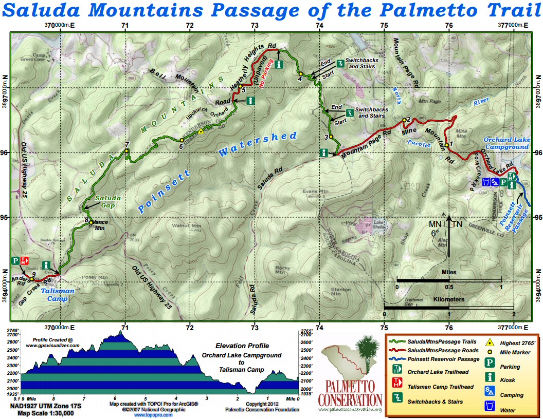
Directions
To Trailhead at Orchard Lake Campground
- From Greenville (approx. 30 miles): Travel north from Greenville on either US 276 or US 25 to Travelers Rest. In Travelers Rest, stay right on US 25 north for approximately 10 miles. About a mile past SC 11, turn right on Old US 25 for 7.1 miles. Turn right on Saluda Road for 3.1 miles (the road becomes Mountain Page Road at the North Carolina line). Watch for Orchard Lake Campground sign and turn right on Mine Mountain Road for 1.3 miles to the junction of Orchard Lake, Fork Creek, and West Fork Creek roads. Curve right on Fork Creek Road for 0.75 mile. Turn left into the Orchard Lake parking area. Continue directions below to trailhead.
- From Spartanburg and Columbia: Take I-26 west into North Carolina. Take exit 67 toward Tryon for 3.4 miles. Turn right on US 176 toward Saluda for 4.7 miles (watch for a brown Pearson’s Falls sign). Turn left on Pearson’s Falls Road for 0.5 miles. Cross Pacolet River and go under railroad trestle. Turn left on Fork Creek Road. Go 4 miles and turn right into Orchard Lake parking area (see below).
- Trailhead and Parking at Orchard Lake Campground: The parking area is behind a split-rail fence just off Fork Creak Road. The trailhead kiosk is at the other end of the open RV camping area.
To Talisman Camp
- From Greenville: Take US 25 north into North Carolina. Take exit 1 off US 25 for .2 miles. Turn right on Bobs Creek Road for 0.9 miles.Turn right at the dead end on Old US 25 south for 0.95 miles to the South Carolina line. Turn right on Gap Creek Road for 0.2 miles (Gap Creek Road turns left here). Continue straight on Anders Road for 0.1 mile. ***
- From Columbia: Take I-26 west into North Carolina. Take exit 54 onto US 25 south (Greenville Highway) for 7.9 miles. Take exit 1 off US 25 for 0.2 miles. Turn left on Bobs Creek Road for 1 mile. Turn right at the dead end on Old US 25 south for 0.95 miles to the South Carolina line. Turn right on Gap Creek Road for 0.2 miles (Gap Creek Road turns left here). Continue straight on Anders Road for 0.1 mile. ***
From Orchard Lake Campground to Talisman Camp
- From the Orchard Lake parking area, turn right on Fork Creek Road for 0.75 miles to the junction of Orchard Lake, Mine Mountain, and West Fork Creek roads. Curve left onto Mine Mountain Road for 1.4 miles. Turn left onto Mountain Page Road for 3.1 miles (the road becomes Saluda Road at the South Carolina line). Turn right onto Old US 25 for 2.2 miles. Turn left on Gap Creek Road for 0.2 miles (Gap Creek Road turns left here). Continue straight on Anders Road for 0.1 mile. ***
***The Trail entrance is across from the Talisman Camp at the NC/SC state line on Old Hwy 25. The designated parking lot is approximately .2 mile down Gap Creek Rd. and right on Anders Rd. to lot on left. Lot has a kiosk with a trail map and is clearly marked Palmetto Trail. No overnight parking is permitted.
No parking is permitted in any of the Talisman Camp parking areas without permission.
Camping
Fee camping available at Orchard Lake Campground.
Notes
- Be sure to read the Greenville Water System Rules. Rules are posted at all Palmetto Trail kiosks and are available online.
- Pack plenty of water and food, as there is no water on the Trail.
Additional Information
Remember to bring trash and waste bags to pack out everything that comes in with you, and Leave No Trace. Thanks!
Saluda Mountains Passage Share Owners
Arthur Byrd
Shannon Laughery
Andrew Rajca
James and Margaret Young
Lucius M. Gulledge
South Carolina Society Children of the American Revolution