About the Peach Country Passage
Region

Difficulty

Length
Activities


Notice:
Howard Gap Rd. at the intersection of Windmill Rd. and N Howard Street has been closed and the street sign removed. The Peach Country Passage still uses this path so look for the Palmetto Trail Sign and proceed on the dirt path to get to the paved part of Howard Gap Rd. You will climb Windmill Hill that offers a fantastic view from the top.
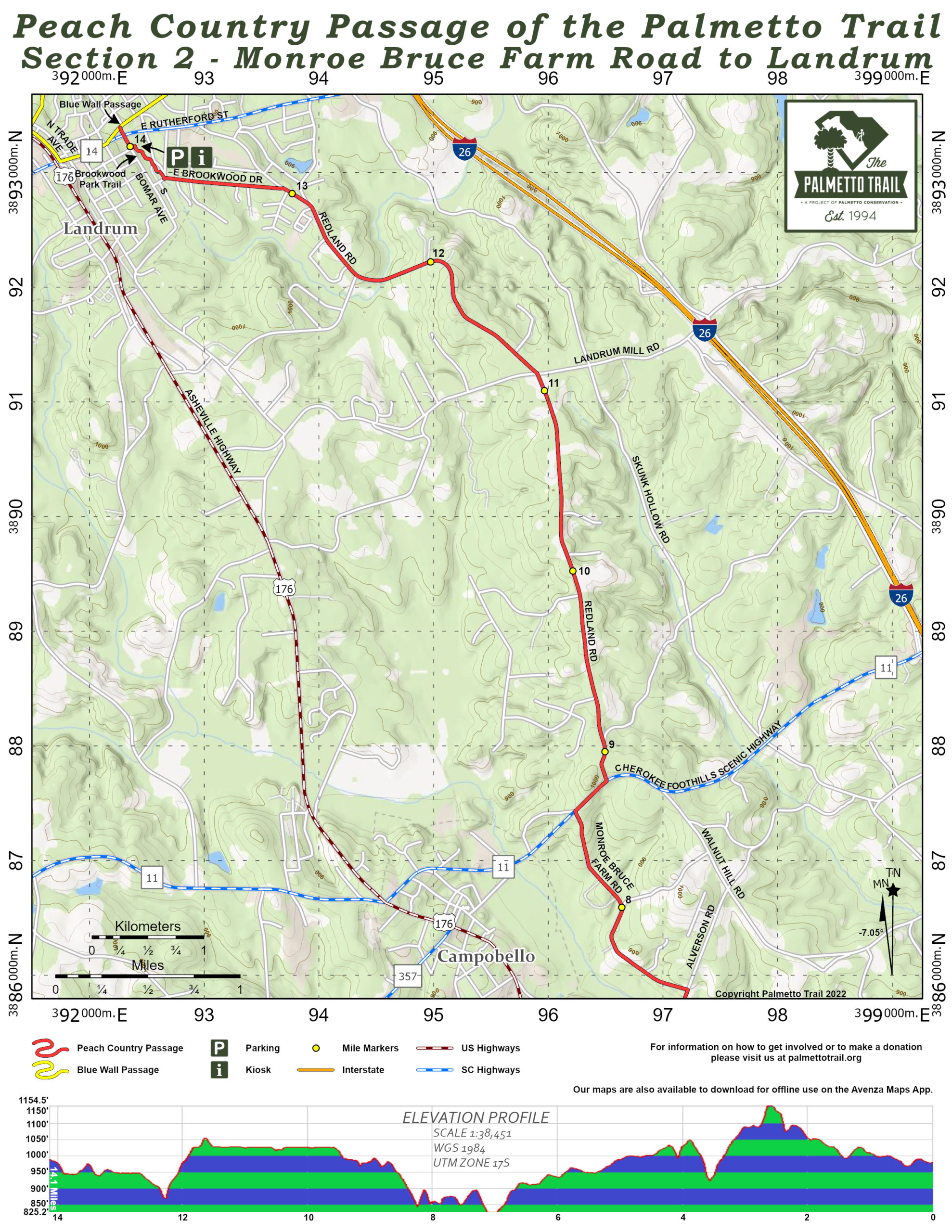
Ideal for bicycling, the scenic Peach Country Passage is routed from Inman to Landrum along back roads dotted with peach orchards. Past the sidewalks of Inman and Chapman High School, cyclists and hikers climb Windmill Hill, the highest point of the passage.
The numerous peach orchards are spectacular when blooming in spring, and remind one of the history and importance of the peach packing industry in the area. Except for a quarter mile on the Cherokee Foothills Scenic Highway (SC Hwy 11) near Campobello, the Trail stays on lightly traveled rural roads. At the end of the final mile through Brookwood Park into Landrum, the Trail connects to the Blue Wall Passage. Turn left and head downtown for unique shops, quaint eateries, and charming B&B inns. Trailheads in Inman, Gramling, and Landrum offer parking and Trail information kiosks.
Interactive Maps Without Wifi
We have partnered with Avenza Maps in order to offer interactive maps that don't require an internet connection. Using the Avenza App, you can download maps onto your mobile device before you hit the trail, so that you locate yourself and be aware of where you are, even in the remotest of places. Offline location helps you stay on track, on the trail, and out of potential danger.
Get the Map
Directions
Trailhead at Inman – Mile 0.2
From Spartanburg: Take I-26 North to exit 15; take US-176 to SC-292. Turn Right on SC-292 (South Main Street). Turn Right on East Main Street. Turn Left on Clark Road and then immediately Left again on South Howard Street. Continue one block to parking area on Left.
From Greenville: Take US-29 (Wade Hampton Boulevard to Lyman SC). Turn Left on SC-129/SC-292 at traffic light in Lyman. Continue on SC-292 to Inman where it becomes South Main Street. Turn Right on East Main Street. Turn Left on Clark Road and then immediately Left again on South Howard Street. Continue one block to parking area on Left.
Trailhead at Gramling – Mile 5.2
From Spartanburg: Take I-26 North to exit 15. Take US-176 to Gramling, SC. Turn Right on Big Mulberry to trailhead and parking.
From Greenville: Take US-29 (Wade Hampton Boulevard to Lyman, SC). Turn Left on SC-129/SC-292 at traffic light in Lyman. Continue on SC-292 to Inman. Turn Left on US-176 to Gramling. Turn Right on Big Mulberry Trace to trailhead and parking.
Trailhead at Landrum – Mile 14
From Spartanburg: Take I-26 North to exit 1. Take SC-14 toward Landrum. Turn Left on South Bomar Road. Turn Left immediately into Brookwood Park and the trailhead and parking.
From Greenville: Take US-29 (Wade Hampton Boulevard to Greer, SC). Turn Left on SC-14 (North Main Street). Continue on SC-14 to Landrum. Cross US-176 and railroad tracks. Turn Right on South Bomar Road. Turn Left immediately into Brookwood Park and the trailhead and parking.
Peach Country Passage Share Owners
South Carolina Society Children of the American Revolution
Bill & Mary Ann Pruehsner