About the Enoree Passage
Region

Difficulty

Length
Activities


NOTICE: Indian Creek bridge is CLOSED
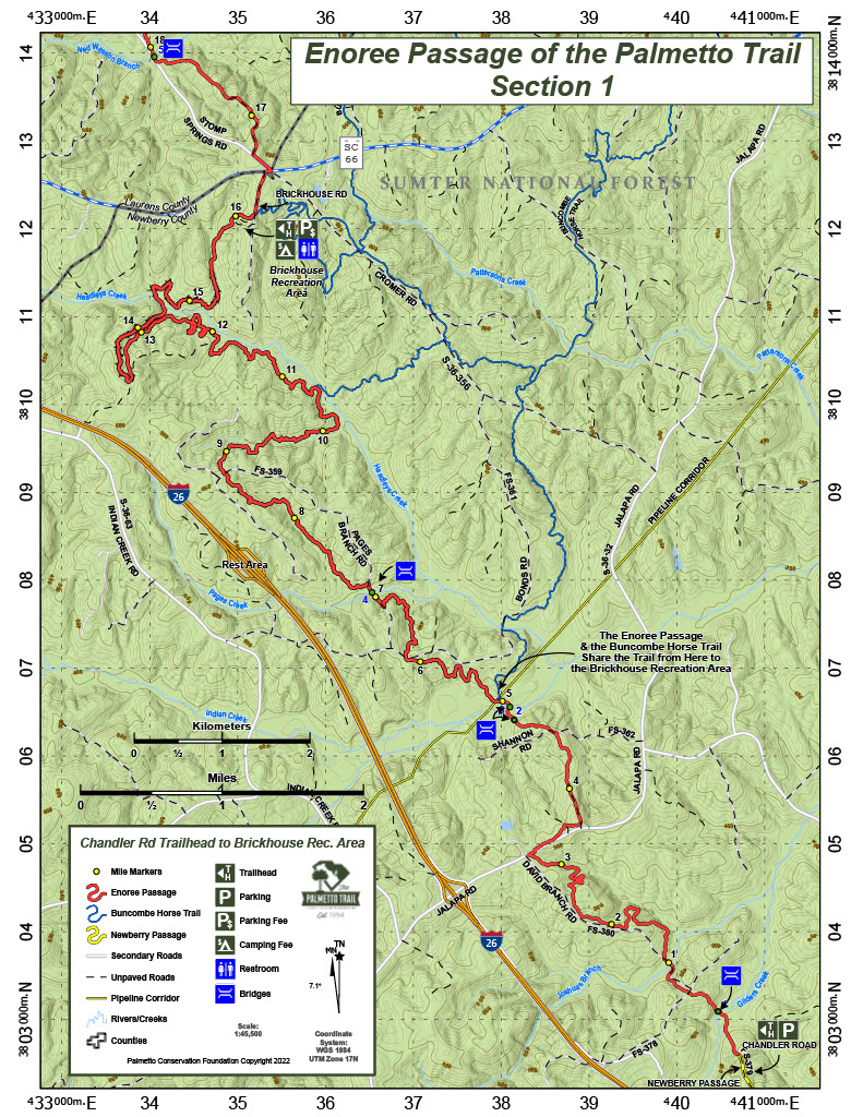
Enoree Passage is 36 continuous Trail miles through Sumter National Forest, linking Newberry, Laurens, and Union counties. The southern trailhead is located at the end of Forest Service Road 379 (Chandler Road) off Old Whitmire Road (SR 81). The Palmetto Trail winds 4 miles through pine ridges and hardwood bottomlands, and crosses Gilders Creek and Indian Creek before joining Buncombe Horse Trail. From the 10 miles to Brick House Campground, hikers and bicyclists share the Trail with equestrians.
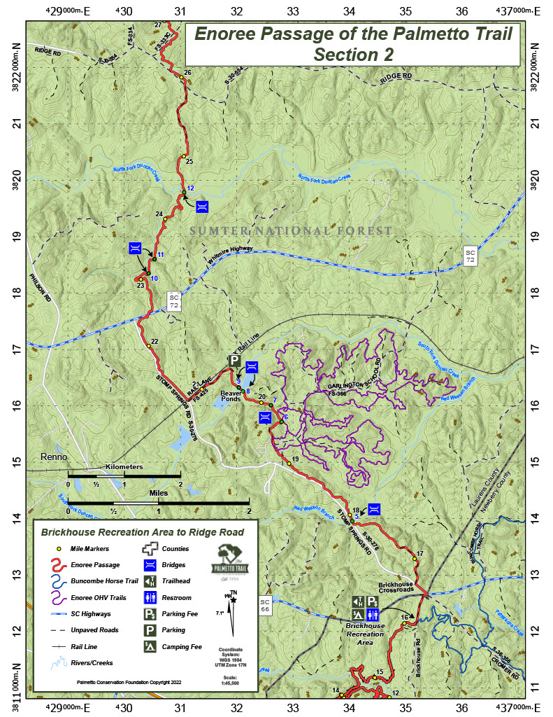
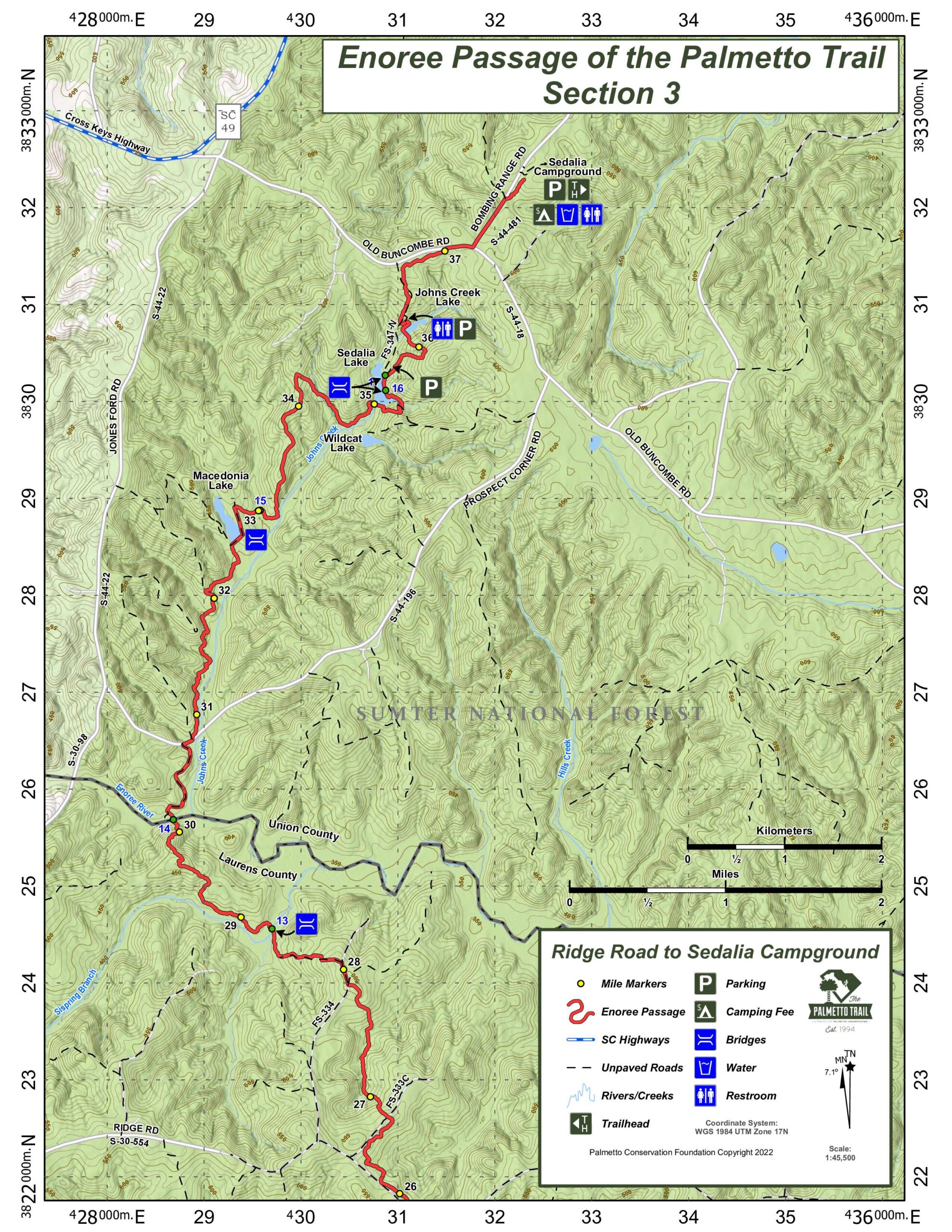
Buncombe trailhead for equestrians is located at Brick House Recreation Area (mile 14) and accessed from SC 66. Heading north, the Trail meanders through some of the most diverse habitats located in the Enoree Ranger District, including a beaver pond, numerous hardwood drains, and the Enoree River corridor. Take a break on the 80-foot bridge for superb views of the river, and stop to fish in Macedonia, Sedalia, and John’s Creek lakes on the way to the northern trailhead at Sedalia Campground.
Trail signs
Interactive Maps Without Wifi
We have partnered with Avenza Maps in order to offer interactive maps that don't require an internet connection. Using the Avenza App, you can download maps onto your mobile device before you hit the trail, so that you locate yourself and be aware of where you are, even in the remotest of places. Offline location helps you stay on track, on the trail, and out of potential danger.
Get the MapDirections
Southern Trailhead (Franklin Road/Chandler Rd):
From Newberry, take US 76 north to SC 81(Old Whitmire Highway), turn right. Travel three miles and turn left on Franklin Road. Immediately turn right on Forest Service road FS 379 (Chandler Road), trail begins at the end of the road turnaround.
From Whitmire, take US 176/SC 121 South for 7 1/4 miles. Bear Right on SC 121 and go 3/4 miles to SC 81 (Old Whitmire Highway) and turn Right. Travel 4.5 miles on SC 81 and turn Right onto Franklin Road. Immediately turn right on Forest Service road FS 379 (Chandler Road), trail begins at the end of the road turnaround.
Middle Trailhead (Brickhouse Recreation Area):
From I26, take exit 60 and head East on SC 66. Travel approximately 3.5 miles and turn right on Forest Service Road FS 358 (Brickhouse Road). Trailhead parking area is 1/4 mile on the Left.
From Whitmire, take SC 66 West and travel approximately 7 miles and turn Left onto FS 358 (Brickhouse Road).
Northern Trailhead (Bombing Range Road):
From Columbia, take exit 72 SC121 toward Whitmire/Union. Keep left on SC121 N/ US 176 W for approximately 16 miles. Turn left on Old Buncombe Rd for approximately 11 miles and turn right on Bombing Range Rd at the church. Sedalia Campground is approximately ¾ mile up on the right.
From Greenville, take I-385 to exit for SC-49 toward Cross Anchor. Cross I-26 and continue toward Cross Anchor. Cross SC-56 at Cross Anchor and continue to SC-18 toward Rose Hill Plantation. Continue on SC-18 about 2 miles to Bombing Range Road on Left (at Church). Sedalia Campground is 3/4 miles on the Right.
Camping
Primitive camping is allowed with a free visitor use permit from the US Forest Service; established campgrounds are available at Brick House (mile 14) and Sedalia (mile 35) -14 day stay limit year round.
Notes
Trailhead parking: Day users go to Buncombe/Palmetto Trailhead Day use parking area.
Camping at Sedalia and Brick House.
The Palmetto Trail shares the Buncombe Horse Trail for 10 miles, from the pipeline (mile 4.2) to Brick House Recreation Area.
Additional Information
USDA Forest Service-Sumter National Forest
20 Work Center Road
Whitmire, SC 29178
Office: (803) 276-4810
Enoree Passage Share Owners
Wayne Beam
Daniel Boozer
Nolan Boozer
Coy & Martha Carter
Suzie Cauwells
S.L. Clarke
Bob Coleman
Wade & Sheely Crowe
Terri Daughtry
Brent Golightly
Daniel Mallard
Allen Montgomery
Glenda Neilsen
Amanda Newbold
Randy Newbold
M/M Don Adams, In Memory of Kevin
Dale Swygert
South Carolina Society Children of the American Revolution


