About the Poinsett Reservoir Passage
Region

Difficulty

Length
Activities

Poinsett Reservoir Passage travels the mountain ridges along the northern boundary of Poinsett Watershed. This pristine watershed of 19,000 acres contains the headwaters feeding Poinsett Reservoir of the Greenville Water System (GW). Rare plants and animals inhabit this unique watershed, and GW enforces strict rules to keep the environment unspoiled. Starting at Vaughns Gap (trailhead for Blue Wall Passage), hikers travel north for about two miles, turn west and trek along Bushy Ridge (border between the Carolinas), then cross into North Carolina for a short hike to Orchard Lake Campground (trailhead for Saluda Mountains Passage). At 3,060 feet, Rocky Spur is the highest peak on the passage.
Trail signs
Interactive Maps Without Wifi
We have partnered with Avenza Maps in order to offer interactive maps that don't require an internet connection. Using the Avenza App, you can download maps onto your mobile device before you hit the trail, so that you locate yourself and be aware of where you are, even in the remotest of places. Offline location helps you stay on track, on the trail, and out of potential danger.
Get the Map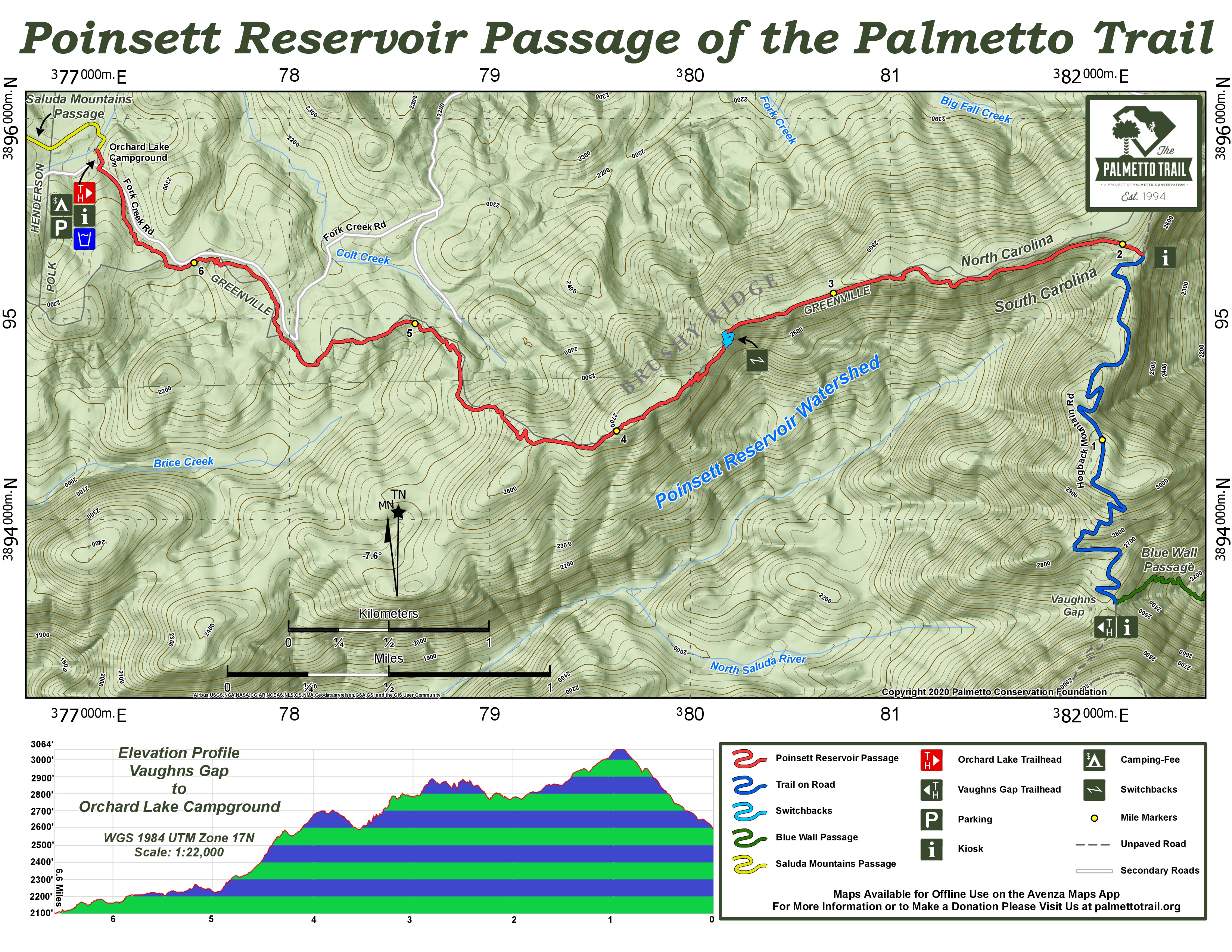
Directions
To Orchard Lake Campground
From Greenville: Take US 25 North past Hwy 11. Turn Right on Old US 25 for 7.1 miles. Turn Right on Saluda Road for 3.1 miles (the road becomes Mountain Page Road at the NC Line). Turn Right on Mine Mountain Road for 1.3 miles to the junction of Orchard Lake, Fork Creek, and West Fork Creek Roads. Curve Right on Fork Creek Road for .75 miles. Turn Left onto the Orchard Lake parking area. *See Below: Trailhead Parking and Kiosk
From Columbia: Take I-26 West into NC. Take Exit 67 to Tryon for 3.4 miles. Turn Right on US 176 towards Saluda for 4.7 miles (You will see a brown Pearson’s Falls sign). Turn Left on Pearson’s Falls Road for .5 miles. Cross Pacolet River and go under railroad trestle. Turn Left on Fork Creek Road. Go 4 miles and turn Right onto Orchard Lake Parking Area.
Notes
Be sure to read the Greenville Water System Rules.
Additional Information
Trailhead Parking and Kiosk
The parking area is inside a split rail fence just off of Fork Creek Road. At the other end of the open RV camping area is the trailhead kiosk.
Poinsett Reservoir Passage Share Owners
Steven Abercrombie
Crystal Adamy
Deidre Adamy
Frank Adamy Jr.
Frank Adamy III
Jennifer Adamy
Jessica Adamy
Tamitha Adamy
Alexander Alperin
Carol Alperin
Andy Barlow
David Bruce Boerma
Richard Benjamin Boerma
Allison Copsey
Maura and Rusty Copsey
Megan Copsey
Ron and Ann Copsey
Boyce Crow
Sandra Crow
Emory Burdette Cullum
John William Cullum, Jr.
Linda Cunningham
W. Chris Daves
Jim & Carolyn Greene
Joseph Griffith
Brent Kossick
Clifton McCallum
Tod Marks
Karl & Amber Sain
Bartow (Bo) Shaw, Jr.
Al & Louise Sill
Robert Stuckless
Daniel Tuner
Bryan & Ginny Walker
Lee & Vicki Willard
South Carolina Society Children of the American Revolution