About the Peak to Prosperity Passage
Region

Difficulty

Length
Activities


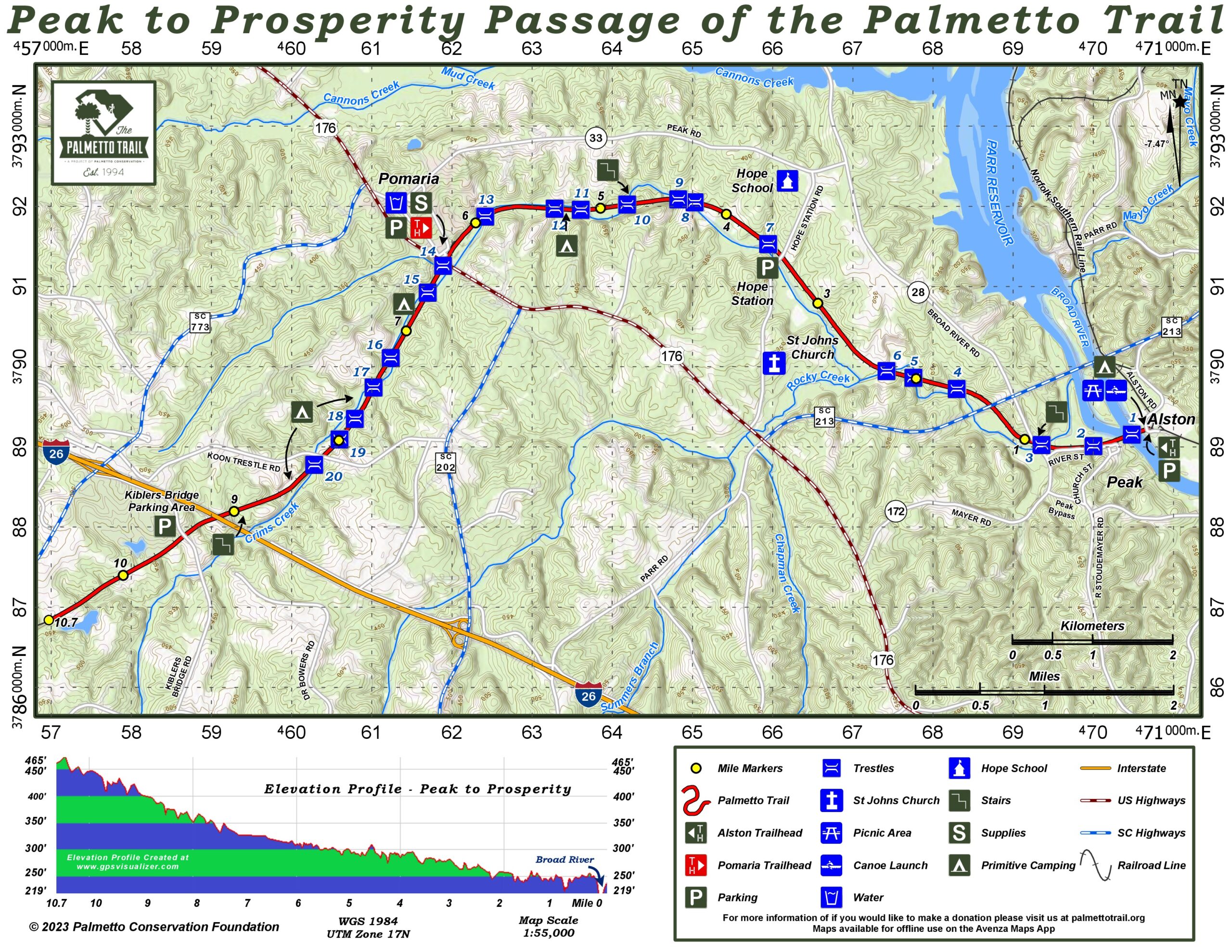
The Peak to Prosperity Passage proceeds west from the Alston trailhead in Fairfield County across the impressive Broad River trestle. The view from the 1,100-foot-long bridge is spectacular, especially when bald eagles soar. Across the river in Newberry County, the rail-trail skirts Peak and cuts an easy swath through piedmont forest to Pomaria and Prosperity. Along the passage, 14 wooden trestles span the meandering Crims Creek where German immigrants settled in the 1730s. The area is known as the Dutch Fork.
Using the railbanking process, Palmetto Conservation purchased the 11-mile, 200-foot wide right-of-way for the passage from Norfolk Southern Railroad. Thanks to SC Parks, Recreation & Tourism for funds to convert the river trestle to a passage treadway, and to Fairfield County for funds to develop the Alston trailhead park.
The first 6.5 miles of the passage were opened in 2009 after two volunteers, Charles Weber and Furman Miller, cleared and decked eight trestles. A grant from SCPRT allowed the team to deck and add handrails to the 1,100-foot-long bridge over the Broad River.
The Peak to Prosperity Passage became a part of the Kids in Parks TRACK Trail program in 2020. Kids in Parks is an expanding network of family-friendly outdoor adventures called TRACK Trails. Each TRACK Trail features self-guided brochures and signs that turn your visit into a fun and exciting outdoors experience. Best of all, you can earn PRIZES for tracking your adventures!
Interactive Maps Without Wifi
We have partnered with Avenza Maps in order to offer interactive maps that don't require an internet connection. Using the Avenza App, you can download maps onto your mobile device before you hit the trail, so that you locate yourself and be aware of where you are, even in the remotest of places. Offline location helps you stay on track, on the trail, and out of potential danger.
Get the MapDirections
We ask that all Trail users respect the private property of the surrounding areas and park only in the designated parking areas. Do not cross private gates or park along the road. Thank You
Alston Trailhead: From Columbia: I-26, exit 97, take US 176 west 11 miles; turn east on SC 213; drive 3.1 miles, turn right onto Alston Road (1st road after the bridge); road changes to unpaved, take right fork, cross RR track and go under the trestle; parking is on the left at the top.
From Spartanburg: I-26, exit 82, take 773 to Pomaria, east on US 176 to SC 213; turn east on 213; follow directions above.
Hope Station Trailhead: From Columbia: I-26, exit 97, take US 176 west 11.1 miles; turn right onto Hope Station Road; drive 1.3 miles to the Trail day-use parking area on the left.
Pomaria Trailhead: From Columbia, I-26, exit 85, take SC 202 east to US 176, turn left and drive into Pomaria, turn right on Angella Street beside Wilson’s grocery; parking is behind the kiosk.
Kibler’s Bridge Trailhead: Take exit 82off I26, turn down frontage road besides golf course, Trailhead sign beyond first curve, turn right before bridge.
Driving Directions BETWEEN Peak and Prosperity Trailheads:
Alston Trailhead to Kibler’s Bridge Trailhead:
Leaving Alston trailhead take a left on Highway 213
Cross the double bridges and continue to US Highway 176
Take a right on US Highway 176,
Pass through the town of Pomaria
Take a left on Highway 773
Cross over I-26 (exit 82) and take a left on Kibler’s Bridge Road, alongside the Mid-Carolina Country Club
After the curve there is a trailhead sign on the right
Turn right before the bridge and drive to parking area
There are three other access points to the trail along this route:
-After turning onto US 176, an immediate right on Hope Station Road will lead to the Hope Station trail access
-When passing through Pomaria the Trailhead is on the right
-While traveling Highway 773, prior to reaching I-26, a left on Koon Trestle Road leads to the Koon Trestle trail access
Camping
The Alston trailhead park provides parking, picnicking, camping, and canoe access on the Broad River.
3 night maximum for camping.
There are now (4) additional campsites along this passage:
- 1 mile east of Pomaria
- 1 mile west of Pomaria
- 1.1 miles west of Pomaria
- 500 Yards West of Koon Trestle Road crossing
Notes
- Sturdy hiking shoes/boots are recommended for the rocky rail-trail.
- For the best hamburgers on the Palmetto Trail, stop in at Wilson’s Grocery, just yards from the Trail in Pomaria.
- Stop and rest at the Jeffrey Paul Breu memorial on the west end of the Broad River trestle.
Peak to Prosperity Passage Share Owners
In Honor of Robert Adams, VI
Mark & Kris Abell
Dianne Bartz
Paul Behles
Mark Berg
Bobby & Mandy Bloom
Hamilton Bogan
Ken Bogan
Matt Bregenzer
Cheyenna Brown
David & Kelly Buckshorn
Thomas Callan
Susan Carter
Davie Coker
Sonny Chunn
Alex Cullum
Maggie Cullum
Sara Cullum
Shelley & Kevin Cullum
Melissa Davis
Parker Davis
Rachel Jean Davis
Virginia Bennett Evers
Susan Coleman Fedor
Charlotte Foster
Brantley & Allison Free
Girl Walkers & Friends
Harry & Pam Girtman
Sharon Givens
Cravens Godbold
Janie & Jack Godbold
Mark & Georgia Goodwin
Mark Hall
Derrick K. Herbst
Hiker Hickman
Amy Coleman Hilton
Bradley S. Hilton
Ken R. Hilton
Hayne Hipp
Robert C. & Linda D. Hochstetler Family
C. Todd Hughey
Missy Hunnicutt
Matthew Hooper
Ben Hornsby
Michael Joseph Huneau
James Hyman
Gregg Jowers, Jr.
William Kelly III
Marilyn G. King
Debi Hilton Kittle
Floyd “Lucky” Kittle
Sumeer & Megha Lal
Ann Lawrence
Larry Leslie
Alston Lippert
J.T. Martin
Sam McCuen
Mike McEntire
Rick & Maureen Mendoza
Jan Merling
Jim Mixson
Ken & Laine Orcutt
Caroline Overcash
Noah Overcash
Carolyn G. Porter
Jennifer Price
John Price
Evan Price
Cravens & Sandra Ravenel
Angela Self
Tonya Stamey
Robin Redding
Sidney and Ben Rex
Preston Rivers
Ashley Rivers
Paul Shealy
Kathi Sill
Tony & Kristin Taffar
Brian Teusink
Beth White
Will White
Lisa P. White
Patrick Alan Young
Elizabeth Zeck
South Carolina Society Children of the American Revolution
University of South Carolina Chapter DAR
Johanna Valenzuela


